For those of us who are passionate about the outdoors, investing in the right navigational tools is a must. With the advancement of GPS and mapping technology, there are plenty of options available to choose from.
Among them is the Garmin Etrex 30x. This GPS system is designed to make navigating the outdoors easier and more accurate than ever before.
In a Rush? Click Here to Check Out The Price!
It is highly recommended by outdoor adventurers and provides a reliable navigational experience. In this blog post, we will review the features of the Garmin Etrex 30x and provide our thoughts on its ability to make your outdoor excursions easier and more enjoyable.
We’ll also discuss its design, functionality and price point. So, read on to learn more about the Garmin Etrex 30x!
Garmin Etrex 30 GPS Test conditions
World leader in GPS, Garmin has renewed its legendary range of GPS etrex in 2011 with the three models etrex 10, 20 and 30. It is the top model, the GPS etrex 30 (with the software 2.80) which has been tested on several hikes: 8 days on the Lycian Way in Turkey, 6 days on the Rota Vicentina in Portugal, 3 days in the Pirin Mountains in Bulgaria, 4 days on the GTJ and 4 days on the Aiguilles Rouges tour in the Alps.
24 days total test to use most of the functions of Garmin etrex 30. Car mode and geocaching function have not been tested.

Garmin etrex 30 gps Specifications
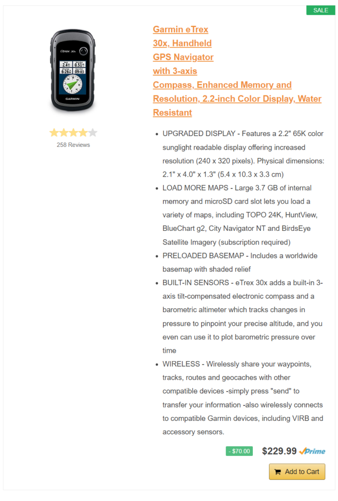
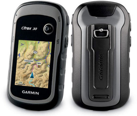
- Dimensions of the device, W × H × D: 5.4 x 10.3 x 3.3 cm
- Screen size, W × H: 3.5 x 4.4 cm; 5.6 cm diagonal
- Screen Resolution, W × H: 176 x 220 pixels
- Screen type: transflective screen, 65,000 color TFT
- Weight: 141.7 g with batteries (weighed at 160 g with batteries)
- Battery: 2 AA batteries (not included); NiMH or Lithium recommended
- Battery life: up to 25 hours
- Waterproof: yes (IPX7)
- High sensitivity receiver: yes
- PC interface: USB
- Product color: Gray and anthracite
- Languages: English, French, Spanish, German, Italian, Dutch, Danish, Polish, Portuguese, Turkish, Romanian …
- Version of the tested software: 2.80
Cards and memory
- Base map: yes (world map background)
- Preloaded cards: no
- Ability to add cards: yes
- Built-in memory: 1.7 GB
- Accepts memory cards: yes, microSD ™ card (not included)
- Waypoints: 2000
- Itineraries (routes): 200
- Trace log: 10,000 points, 200 recorded tracks
Functions
- Automatic route definition: yes, (with optional mapping for detailed routes)
- Electronic compass: yes (compensated inclination, 3-axis)
- Touchscreen: no
- Barometric altimeter: yes
- Digital Camera: no
- Custom maps compatible: yes
- Device-to-device transfer (wireless sharing of data from similar devices): yes
Garmin etrex 30 Accessories
- USB Cable
- No products found.
- Micro SD memory card (optional)
- No products found.
- No products found.
- Garmin TOPO! Map
First impression: first step, screen, autonomy
The Garmin etrex 30 GPS comes in a small box with a quick start manual and a USB cable. The complete user manual can be downloaded from the Garmin website. No batteries provided.
AA batteries are easy to install. Alternatively, use alkaline, NiMH or lithium batteries. NiMH or lithium batteries are recommended for longer life because alkaline batteries are less resistant to cold.
If the GPS is not used constantly, the range can be 25 KM (4 days of walking), otherwise it is much less. Rechargeable batteries (NiMH) have a lower impact on the environment but they also require bringing a solar panel and / or a battery charger.
Note that the backlight of the screen is adjusted by pressing the light button once. To change the level, use the Thumb StickTM (joystick) on the left or right. As well as the delay of the backlight can be set from the config / screen menu. This is important for maximizing battery life.
The only big black spot: the absence of a standby function that would allow you to record only the track while locking the GPS.
The 65,000 color TFT transflective screen is not exceptionally high resolution (176×220 pixels) but the brightness is good and the visibility very correct even in bright light. It is not tactile either. We navigate through the menus using the Thumb StickTM. The menus are customizable according to its use.
GPS reception
The GPS is turned on by simply pressing the lower right button (longer press to switch it off).
Satellite reception is fairly fast and accurate at 3 meters thanks to the Teseo 2 antenna from STMicroelectronics which captures several GPS systems, American and Russian (Glonass).
The receiver can use up to 24 satellites more than one GPS.
In fact, satellite reception is effective, including in forest and in cached areas. On starting up, the GPS sometimes fails to receive the satellites even in open ground and from time to time it loses the reception for no apparent reasons.
This is a bug that I have noticed several times and that other users also told me. Simply switch off the device and turn it on again or remove the batteries and put them back in order to have everything work again.
The cumulative elevations are also sometimes wacky especially in the positive elevations.
Map Backgrounds, Waypoints, Routes and Tracks: Customize Menus
With the etrex 30 GPS, you can load up to 2000 waypoints, 200 routes (routes in the Garmin software) and 200 tracks. It’s largely enough.
To create, search, modify or delete a waypoint, start, search or modify a route, save, display or delete a track, you must leave the map by clicking on the right side button “back” and enter the contextual menu.
A small shortcut would not have been too much! Since there is none, it is important to customize the GPS menus (in the context menu, click on the left-hand “menu” and select “modify order”).
For my part, I made trace all the items relating to the waypoints, routes and tracks, then those on the satellite reception, the altitude profile and the compass for the “leisure” profile.
If you want to use the GPS in another configuration (automobile, geocaching or at sea), just switch to one of these profiles and customize the menus. Convenient !
For the modification of the waypoints and the correction of the tracks, I much prefer to use the software Basecamp free download on the site of Garmin (to download Basecamp). It still looks better on a computer screen and it’s more user-friendly.
About roads, it is possible to display the active route. This function is interesting. After preparing the hike in advance on Basecamp or GoogleEarth, you can find the waypoints near the active route.
Imagine that you have marked a waterfall. If your active route passes nearby, it will tell you and the number of miles to go to get there.
On the other side of the coin, if you leave the itinerary prepared in advance, the distances are no longer accurate.
The global map background provided with GPS is poor for a hiker. Optional maps are available for greater accuracy: Raster Bird Eyes Select Garmin or vector (Topo France Entiere V3 Garmin for example) but they are quite expensive. The broke and the stingy can download the OpenStreetMap map database downloadable here for your country.
To navigate to a destination, two options: use the “Where to go” function or the compass. The “Where to go” function is intuitive and allows you to connect a specific point as the crow flies. I used it in Portugal where I knew my base for the night but did not have the trace or the basic map sufficient to identify the small roads.
The serax 30 has a 3-axis electronic compass. Two ways coexist to navigate: the course pointer and the bearing pointer. I prefer to use the bearing pointer which indicates with a red arrow the direction of the destination. The pointer of course may walk you if the obstacles are numerous (trees, rocks …).
The altitude profile provides indications of altitude difference and altitude. It is also here that the altimeter can be calibrated.
The trip calculator shows the average, maximum, trip odometer, trip time, and stop time. Personally, in hiking mode, I use this function very little.
Strength and waterproofness of the GPS
The Garmin etrex 30 GPS is waterproof according to IPX7. It can therefore withstand immersion in water at 1 meter for 30 minutes.
For the purpose of the test, the GPS was therefore immersed in a fountain for 5 minutes. The satellite reception went off (normal). After drying it, it worked again as the first day.
The device is robust but the screen is scratched fairly easily. To protect it further, it is possible to buy a carrying case.
Strong points
- IPX7 sealing
- Autonomy
- User-friendly navigation and customizable menu
- Fast and accurate satellite reception (excluding bug)
- Active route
- Share wireless data with another Garmin technology-enabled GPS
- Value for money including a barometric altimeter and a 3-axis electronic compass
Weak points
- Software bugs: cumulative elevations, stops, satellite reception
- No keyboard lock
- No standby function
- No touch screen
Conclusion
The Garmin Etrex 30 is a user-friendly and robust GPS for all types of hikers and outdoor activities.
Waterproof, with an autonomy of almost 25 hours any option on and its advanced functions, barometric altimeter and 3-axis electronic compass in mind, it proves to be an effective instrument on the ground and an excellent quality / price ratio despite the recurring bugs of the software and the few functions we would like to see added (but who does not?).
Remember to follow software updates and hope that Garmin corrects the bugs.
